10 Best Coastal Trails in South Korea for Breathtaking Sea Views

South Korea's coastline is a drama of contrasts: jagged volcanic cliffs that drop into deep turquoise waters, ancient pine forests that lean over the surf, and modern urban skylines that shimmer across the bay. While the inland mountains get much of the hiking glory, it is along the "edge of the peninsula" that you find some of the country's most breathtaking and accessible walking paths.
From the 770-kilometer Haeparang Trail running up the East Sea to the iconic volcanic circuits of Jeju Island, the coastal trails of Korea offer a sensory experience that mountain peaks simply cannot match — the constant rhythm of the waves, the smell of salt air, and the freshest seafood in the world waiting at the end of the path.
Whether you're looking for a rugged, wind-swept cliff walk or a gentle stroll through a colorful fishing village, South Korea has a coastal trail for you. Here are 10 of the best, each with full logistics so you can plan immediately.
Trail Overview: At a Glance
| Trail | Region | Distance | Difficulty | Best Season |
|---|---|---|---|---|
| Igidae Coastal Walk | Busan | 4.7 km | Moderate | Spring, Autumn |
| Taejongdae Resort Loop | Busan | 4 km | Easy-Moderate | Spring, Autumn |
| Haeundae Blue Line Path | Busan | 4.8 km | Easy | Year-round |
| Haeparang Trail Section 1 | Busan→Gijang | 20 km | Moderate-Hard | Spring, Autumn |
| Jeongdong-Simgok Badabuchae-gil | Gangneung | 2.86 km | Easy | Spring, Summer |
| Naksan-sa Temple Path | Yangyang | 3 km | Easy | Spring, Autumn |
| Geoje Windy Hill Path | Geoje | 1.5 km | Easy | Year-round |
| Namhaeparang Trail | Namhae | 74 km (multi-day) | Moderate | Spring, Autumn |
| Handam Coastal Walk | Aewol, Jeju | 1.2 km | Easy | Year-round |
| Jeju Olle Route 7 | Seogwipo, Jeju | 17.6 km | Moderate | Spring, Autumn |
The Busan Trio: Urban Cliffs and Island Views
Busan is the coastal hiking capital of Korea. The city doesn't just meet the sea; it clings to it. Every hillside reveals a new angle on the East Sea, and the local seafood culture means every trail ends near excellent food.
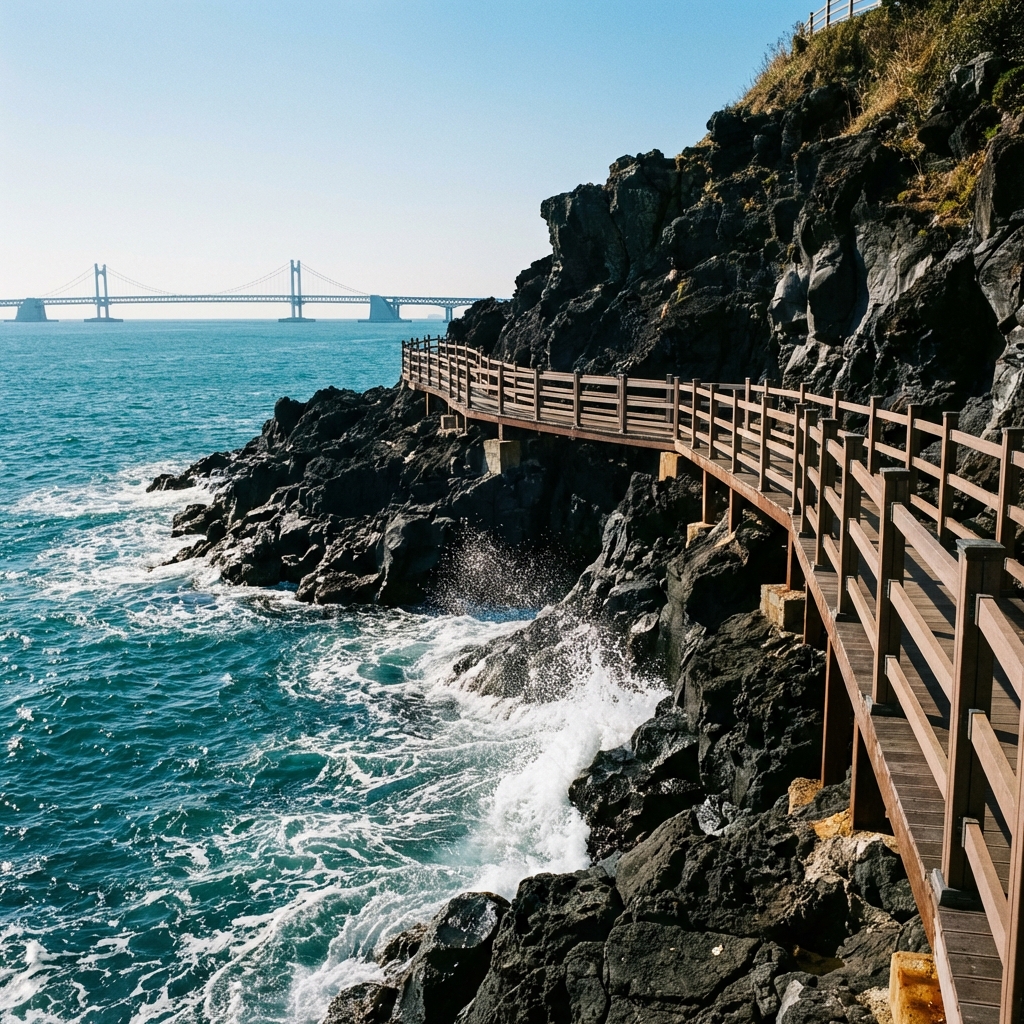
1. Igidae Coastal Walk (이기대 해안산책로)
Commonly cited as the most scenic trail in Busan, the Igidae Coastal Walk is a 4.7-kilometer cliffside path through forests and rocky coastal outcroppings.
Trail Details:
- Distance: 4.7 km one way (9.4 km round trip, or take the return bus)
- Time: 2–3 hours one way
- Difficulty: Moderate — steep stairs, some rocky sections, but well-maintained throughout
- Elevation: Max 80m above sea level
What You'll See: The highlight is the unobstructed view of the Gwangandaegyo Bridge and the Marine City skyline framed against the open East Sea. In spring, the cliffside wildflowers compete with the turquoise water for your attention.
Access:
- Take Bus #108 or #22 from Kyungsung University Station (Line 2) to Oryukdo Sunrise Park. This is the trail's start.
- Alternatively, take a Kakao T taxi to "이기대공원" (Igidae Park) — approximately ₩8,000–₩12,000 from central Busan.
End Point Food: The trail ends near the Namcheon neighborhood — walk 10 minutes to find Busan's famous cold noodle restaurants (milmyeon).
2. Taejongdae Resort Park (태종대)
Located on the southern tip of Yeongdo Island, Taejongdae is famous for its towering volcanic cliffs and the historic Yeongdo Lighthouse (built 1906, still operational).
Trail Details:
- Distance: 4 km loop
- Time: 1.5–2.5 hours
- Difficulty: Easy-Moderate — mostly paved, some descents to viewpoints
The Cliff Experience: The cliffs of Taejongdae drop 50–60 meters straight into the sea. On clear days, you can see Tsushima Island, Japan.
Access:
- Bus #88 from Nampo Station (Line 1) to Taejongdae Terminal (30 min ride). Then the "Danubi Train" or walk the loop.
- Danubi Train Option: ₩3,000 return fare takes you to major viewpoints if you want to save energy for the cliff viewpoints themselves.
The Hidden Pebble Beaches: Walking the loop (rather than taking the train) lets you descend to small pebble beaches where haenyeo (female divers) often sell fresh seafood directly. Eat raw sea urchin (sea urchin bibimbap) right there for ₩15,000–₩25,000.
3. Haeundae Blue Line Park (해운대 블루라인파크)
For a more modern experience, this 4.8-kilometer path follows an abandoned coastal railway from Mipo to Songjeong, with constant sea views.
Trail Details:
- Distance: 4.8 km one way
- Time: 1–1.5 hours walking
- Difficulty: Very easy — flat, paved path following the old rail bed
The Blue Line Experience: What makes this trail unique is the Sky Capsule — small 4-person gondola capsules that travel the railway at window height above the coast. Booking a capsule for the return leg is a highlight many visitors build their Busan day around.
- Sky Capsule price (2026): ₩30,000 for 2 people, ₩40,000 for 4 people (return trip, one direction only)
- Beach Train (Haetori): A restored vintage train also runs the route. Tickets ₩8,000 per person.
Book in Advance: Sky Capsule tickets sell out weeks ahead on weekends. Book at blueline.or.kr.
The Mighty East Coast: Haeparang Trail and Beyond
The East Sea (Donghae) is characterized by deep, clear water and a rugged, straight coastline with dramatic rock formations formed by wave action over millennia.
4. Haeparang Trail — Section 1 (해파랑길 1코스)
The Haeparang Trail is Korea's longest long-distance trail at 770 kilometers, running from the southern tip of Busan all the way to the North Korean border. Section 1 is the entry point.
Trail Details:
- Section 1 Distance: 20 km
- Time: 7–9 hours (full day)
- Difficulty: Moderate-Hard — significant elevation changes near Gijang cliffs
- Start: Oryukdo Sunrise Park, Busan
- End: Ilgwang Beach, Gijang County
For Shorter Versions: Most casual hikers do the first 8–10 km (to Gijang Port) and stop there for lunch. Gijang is famous for its seafood — particularly daeguki (large crab broth) and fresh sashimi.
The Durunubi App: Download this free app before your hike. It provides real-time GPS positioning on the Haeparang Trail, offline maps, difficulty ratings per section, and digital stamp collection. You can track your progress across all 770 km over multiple visits.
5. Jeongdong-Simgok Badabuchae-gil (정동심곡 바다부채길)
This 2.86-kilometer trail is built into a 23-million-year-old marine terrace — South Korea's only one. Essentially, you are walking along an ancient seabed that was lifted by tectonic activity and is now a cliff path.
Trail Details:
- Distance: 2.86 km one way (5.72 km round trip, or arrange pickup)
- Time: 1.5–2 hours
- Difficulty: Easy — well-maintained path with railings throughout
- Location: Gangneung, Gangwon Province
The History: This was a military restricted area for decades (closed to civilians). The boundary between North and South Korean territorial waters runs not far offshore, and the East Sea coastline here was heavily monitored. It opened to public hikers in 2017 and immediately became one of Korea's most visited trails.
Access: From Gangneung Station, take Bus #112 to Jeongdongso-gil Stop (~35 min). Entry fee: ₩3,000 per person.
Reservations Required: Due to the narrow path, timed entry reservations are mandatory (maximum 1,000 visitors per day). Book at the Gangneung Tourism website or call 033-640-5419.
6. Naksan-sa Temple Coastal Path (낙산사 해안길)
This trail combines coastal beauty with ancient Buddhist spirituality. The path leads through the Naksan-sa temple complex, where the Hongryeonam Hermitage sits perched on a cliff directly over the crashing waves — one of the most dramatic religious structures in Korea.
Trail Details:
- Distance: 3 km loop
- Time: 1–1.5 hours
- Difficulty: Easy
- Location: Yangyang-gun, Gangwon Province
- Temple Entry Fee: ₩3,000 per person
The Hermitage: Hongryeonam can only be reached by a short, steep path down the cliff. The hermitage sits so close to the water that waves occasionally splash the windows during storms. The view from the small wooden platform looking out to sea is one of Korea's most profound.
Getting There: From Sokcho Intercity Bus Terminal, take Bus #9 to Naksan-sa (~20 minutes).
The Southern Charm: South Sea and Geoje
The South Sea (Namhae) is a labyrinth of thousands of islands, emerald bays, and terraced hillsides cascading into the water.
7. Geoje Island's Windy Hill (바람의 언덕)
While brief, the walk to Windy Hill on Geoje Island provides one of Korea's most photographed coastal panoramas.
Trail Details:
- Distance: 1.5 km round trip
- Time: 45 minutes
- Difficulty: Easy — wide paved path
- Location: Geoje, South Gyeongsang Province
The Icon: A red windmill on a sea-facing hillside against the blue expanse of the Hallyeohaesang National Park. This image has appeared in numerous K-dramas and is recognized across Asia.
Getting There: From Geoje Intercity Bus Terminal, take Bus #53 to Dohyang Station (~45 min).
Combine With: The nearby Gujora Beach (5 min drive) for swimming and seafood after the walk.
8. Namhae Haeparang Trail (남해 해파랑길)
The "southern brother" of the main Haeparang Trail, this multi-day route winds through the hidden coves, pine forests, and terraced rice paddies (다랑이논) of Namhae County.
Overview:
- Total Distance: 74 km across 4 primary sections
- Best Done In: 3–4 days with overnight stays at local minbak (guesthouses)
- Difficulty: Moderate overall, with some steep coastal climbs
- Highlight Section: The Garye Coastal Walk (Section 3) passes through the village of Seo-myeon, where terraced rice paddies drop straight to the sea — one of the most visually stunning landscapes in South Korea.
Accommodation: Minbak guesthouses along the route charge ₩40,000–₩60,000 per night for a room. Book ahead in spring (cherry blossom season) and autumn (foliage season).
Jeju Island: The Coastal Masterclass
No list of Korean coastal trails is complete without Jeju. The island is essentially one giant coastal trail network, with the 26-section Olle Trail serving as the backbone.
9. Handam Coastal Walk (한담 해안산책로)
Located in Aewol on western Jeju, this trail is famous for its exceptionally clear, emerald-colored water.
Trail Details:
- Distance: 1.2 km one way (2.4 km round trip)
- Time: 45–60 minutes
- Difficulty: Very easy — flat, paved seaside path
- Best Time: Sunset. The western location means spectacular sunsets across the East China Sea.
The Café Culture: The end of the Handam path connects to a string of architectural cafés built directly over the water — Café Ondal, Monsant, and A-Land are the most photographed. Each offers floor-to-ceiling ocean windows and matcha or jeju citrus drinks. Expect ₩8,000–₩15,000 per drink.
10. Jeju Olle Route 7 (올레길 7코스)
Considered by many experienced hikers to be the best single section of the 26-route Jeju Olle Trail system, Route 7 runs along the rugged southern coast of Jeju Island.
Trail Details:
- Distance: 17.6 km
- Time: 5–6 hours
- Difficulty: Moderate — mostly flat with some coastal scrambles
- Start: Oedolgae Rock (외돌개), Seogwipo
- End: Wolpyeong Port
What You'll See:
- Oedolgae Rock: A 20-meter volcanic pillar rising from the sea, said to be the body of a general who turned to stone waiting for his wife.
- Soggol Stream (속골): Fresh water meets the sea in a dramatic gorge.
- Munseom (문섬): "Moon Island," a volcanic islet visible offshore from the trail — one of the premier dive sites in Asia.
Jeju Olle Passport: At every Olle trailhead, you can collect a rubber stamp in your Olle Passport booklet. Completing all 26 routes earns a special certificate. Passports are ₩3,000 at the trailhead information office.
Packing Guide for Coastal Hikes
| Item | Why You Need It |
|---|---|
| Trekking sandals or waterproof trail shoes | Rock surfaces near the water can be slippery even on dry days |
| Sun protection (SPF50+, hat, UV sleeves) | Coastal UV exposure is intense; no forest canopy on most sections |
| Wind layer | Even in summer, cliff tops funnel cold wind from the sea |
| 1.5–2L water | Fewer water sources than mountain trails; plan ahead |
| Snacks | Seafood restaurants are at trail ends, not midway |
| Durunubi app (downloaded offline) | GPS mapping for all national trails in Korea |
| Cash (₩20,000–₩40,000) | Trailhead snack vendors and small restaurants are cash-preferred |
| Sunscreen (reapply every 2 hours) | Salt air and coastal breezes mask sun intensity |
Best Seasons for Coastal Trails
- April–May (Peak Spring): Wildflowers on the cliffs, cherry blossoms near temple trails, moderate temperatures, clear skies. Best overall season.
- June–July (Early Summer): Clear water visibility for coastline appreciation; monsoon rains arrive late June.
- August: Avoid — peak humidity and typhoon season. Some trails close after heavy rainfall.
- October–November (Autumn): Second-best season. Lower crowds than spring, excellent visibility, cooler walking temperatures.
- December–February: Coastal wind chill is significant. Many shorter trails remain open and are dramatically beautiful (rough seas, snow on cliffs in the north), but require proper winter gear.
End-of-Trail Seafood: What to Eat After Each Hike
One of the unsung pleasures of coastal hiking in Korea is that every trail ends near exceptional seafood. Korean fishing villages and port towns take immense pride in the freshness of their catch, and the best meal of your trip might be the one you eat 200 meters from a trailhead.
| Trail | Nearby Seafood Spot | What to Order | Price |
|---|---|---|---|
| Igidae Coastal Walk | Gwangalli Beach seafood restaurants | Hoe (raw fish), ganjang gejang (soy crab) | ₩20,000–₩50,000 |
| Taejongdae | Pebble beach haenyeo vendors | Sea urchin bibimbap, raw abalone | ₩15,000–₩30,000 |
| Haeparang Section 1 | Gijang Port seafood market | Snow crab broth (daeguki), sashimi sets | ₩25,000–₩45,000 |
| Naksan-sa Temple Path | Sokcho tourist area | Ojingeo sundae (squid stuffed with noodles) | ₩10,000–₩15,000 |
| Jeju Olle Route 7 | Seogwipo Port market | Jeonbok juk (abalone porridge), halmang guksu | ₩12,000–₩20,000 |
| Handam Coastal Walk | Aewol Harbor | Mul hoe (raw fish in cold broth), heukdomuk (black noodle fish cakes) | ₩15,000–₩25,000 |
The Golden Rule: If there are fishing boats tied up nearby, the seafood is local and fresh. If you're in a tourist-heavy location without boats, be more selective about where you eat.
Conclusion
The "edge of Korea" is where the country's natural power is most visible. Whether you're traversing the ancient terraces of Gangneung or the urban cliffs of Busan, these 10 trails offer a perspective of the peninsula that mountain summits simply can't provide. As you start building your 10-Day South Korea itinerary, setting aside a day or two to explore the coastline is a must for balancing the bustling city components. If you find yourself in the capital, you can still experience brilliant outdoor climbs by hiking Bukhansan National Park directly on the edge of the metropolis. For a dedicated trip focusing purely on sand and sun, review our guide to Camping in South Korea: Best Glamping Sites to find coastal overnight options near these trails. Before you choose a route, pair this list with our hiking etiquette guide for Korea so the trail culture is not a surprise when you arrive. If you want a mountain benchmark rather than a sea-view walk, compare these routes with Seoraksan National Park. And if you want a softer recovery day after a big hike, the healing stays and forest therapy guide is the natural follow-up.